Saving Lives with Node.js
(and the Air Ambulance Service)
by Nigel Hanlon
Introductions
Who am I?
Nigel Hanlon
Senior Software Developer at OpenApp
Work primarily on GIS.
(I develop maps to solve problems)
Talk Outline
Air Ambulance service, from 999 to hospital door
Health Atlas AeroMedical System
Web mapping and GIS technology
ESB Power lines
Real time Aircraft tracking
Finding Patients with LocateMe112
Future developments
Questions and Answers
The Air Ambulance service
From 999 to hospital door
What service do you require?
All 999/112 calls are answered by ECAS
Emergency Call Answering Service
Ambulance requests are handled by the National Emergency Operations Centre
Based in Tallaght and Ballyshannon
Ambulance Dispatch
Paramedics arrive and assess the situation
An Air Ambulance can be called if:
- Time critical injury or condition
- Journey to appropriate hospital by road is greater than 45 minutes
- No Advanced Paramedic or Doctor available
The Air Desk
Responsible for managing air ambulance missions
Passes on mission details to responders
Coordinates with other agencies that may be required
Custume Barracks Athlone
Pilots receive mission location and select landing zone
Advanced Paramedic briefed on patient condition
Take off in 5 minutes or less
On route
From Athlone to the West Coast in 30 minutes
The pilots use a printed datasheet of the landing zone
Datasheet shows ESB wires, buildings and other obstacles
On Scene
Leaving for hospital
Arriving at hospital
Health Atlas Ireland AeroMedical
What is it?
A Web based system for managing Air Ambulance Missions
Operating 24/7 for the last 6 years
Developed in cooperation with multiple agencies
Demo Time
(because what could possibly go wrong?)
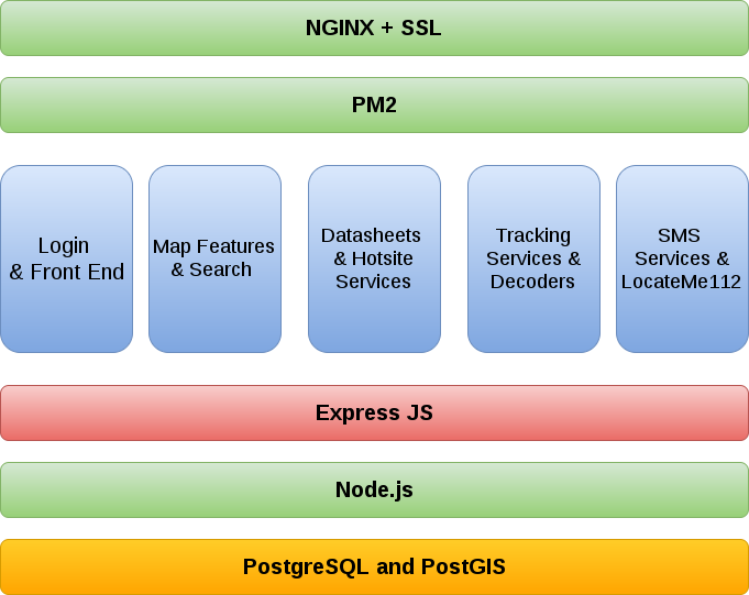
Front End
- OpenLayers
- Socket.io
- proj4.js
- jQuery
- jQueryUI
- moment
- Google Maps API
Back End
- Express
- Socket.io
- pg
- ldapjs
- mocha
- winston
- handlebars
- phantomjs
- pm2
Stack overview
Web Mapping and GIS
Lines, Points and Polygons
1,000+ Service Features (Hospitals, Garda etc)
4,000+ Helisite Points
30,000 Motorway Markers & ERT Features
68,051 Gazetteer Points
75,825 High Voltage Lines
910,033 Medium & Low Voltage Lines
2,313,218 Address Points
PostgreSQL and PostGIS
We use PostgreSQL as our database of choice.
PostGIS Extension - provides spatial objects and location queries.
node-postgres module by Brian Carlson
Node JS Feature Server
Inspired by the Python Project of the same name.
Provides a RESTful Geographic Feature Service
Serves GeoJSON layers from PostgreSQL tables
Provides search interfaces for known layers
OpenLayers
A powerful, feature packed library for mapping data.
Supports vector layers using GeoJSON
Proj4.js Library for projection support
Bounding Box queries for larger datasets like ESB powerlines.
ESB Power lines
The Data
Data provided for entire ESB power grid
Available under special licence
Updates available every 6 weeks
Delivered via DVD in CAD format
Processing
Converted to a GIS format using GDAL Library
Rules applied in SQL to remove all unwanted features.
Remaining overhead power lines checked against paper maps.
High voltage
Low & Medium Voltage
Real time Aircraft Tracking
Irish Aircorps
Data provided by Track24 based Canada
Onboard Device broadcasts GPS location via Iridium Satellite link
Low update resolution but Satellite time is expensive
Location updates POST'd directly to tracking server
Irish Coast Guard
Tracking data provided by Dept. of Transport
Locations captured by AIS (Automated Identification System)
AIS is an automatic tracking system used for collision avoidance on ships
Data streamed via TCP in AIS message format
Bespoke decoder translates messages to GIS coordinates
AIS, 6-bit wonder
!BSVDM,1,1,,A,93fJulhA@0OSEGfNTdm@0=h20hQ3,0*1F
6 bit ASCII encoding representing a binary message.
Character '9' is ASCII value 57. We subtract 48 from this and get 9 which is '001001'
001001 000011 101110 011010 111101 110100 110000 010001 010000 000000 011111 100011 010101 010111 101110 011110 100100 101100 110101 010000 000000 001101 110000 000010 000000 110000 100001 000011
Playing with Bits
Buffers deal with Bytes, not bit level operations
parseInt(value, radix) is your friend!
In AIS, offsets and bit lengths represent different attributes.
Altitude begins at bit 38 and is 12 bits in length
Altitude is parseInt('000001000101', 2) which gives us 69 metres.
From Database to Screen
All tracking messages are stored in PostgreSQL
Tracking data is streamed to front-end sessions via WebSockets
An INSERT on the database triggers a 'push' event, updating all open sessions.
Only the last 24 hours of tracking data is held.
LocateMe112
Overview
Air Ambulance missions require location for dispatch.
ECAS can pin point the location of land line calls.
In the last 5 years, over two thirds of 999 calls are now from mobile devices.
Ireland does not implement the Radio Resource Location Services Protocol
Closest cell tower gives county or urban area match at best.
LocateMe112
Majority of people now have a Smartphone with GPS
Browser based GeoLocation allows us to request and report device location
Unique SMS link sent each person
Small web application activates GPS, POST's location to server
Developed in collaboration with the Irish Aircorps
Stats
4,300 Text Messages sent
3,600 delivered successfully.
Over 1,525 people found using LocateMe112
Device breakdown: 45% Android, 52% iOS, 3% Others
Average location accuracy is 220 metres
Future Developments
Thank you.
Follow me on Twitter for updates: @nigelhanlon